Objectives

Cycling isn't always about miles and riding faster than your club mates. Sometimes, you have to slow down, stop occasionally, look around and experience the beauty and uniqueness of your surroundings rather than concentrating on your heart rate, cadence, or the rider's wheel in front of you. The intent of this blog is to write about where I've set some goals for the ride, and the experiences of getting there.

Sunday, January 30, 2011

Empire Mine Road

There's a 3.25-mile hilly stretch of road in Antioch called Empire Mine Road. It runs from Mesa Ridge Road at the north end, to Deer Valley Road at the south (http://ridewithgps.com/routes/274051). It’s just about the quietest stretch of road in East County. The City of Antioch closed the road a few years ago to prevent illegal dumping, but allows hikers and cyclists to use it. It was a quiet road then and is even quieter now.


The mostly out of date but still relevant book by Grant Petersen of Bridgestone and Rivendell Bicycles fame, “Roads to Ride” (1989) describes it as “An often neglected farm road in northeastern Contra Costa County. It’s narrow with a gravelly surface and sloping shoulders. There’s almost no traffic.” The statement still rings true, except the part about the gravelly surface. There’s no gravel and the pavement is fair (chip seal). As an aside, there's companion book called "Roads to Ride South." These books feature an elevation profile, road description, rudimentary maps, and black and white photos of various roads in the Bay Area. It would be nice if these books were revised someday.


There's a fire road where you can access the Star Mines area of Black Diamond Regional Preserve. You have to hop over two gates, though. You ride past the old town site of West Hartley.


If you want to do a short, scenic, moderately hilly ride with no traffic, Empire Mine is the road to ride. 

Friday, January 28, 2011

Mt. Diablo

Took a day off work today- too much vacation saved up. What better way to spend a vacation day than to ride!

Drove over to Heather Farms Park in Walnut Creek. I either start there or at Arbolado Park, which is a bit closer, when I ride the mountain. I was supposed to meet some Valley Spokesmen Club members, but none showed. It was very foggy and cold today. Perhaps it was that or the fact that is was a weekday, after all.


However, at ~550' elevation, the fog gave way to sunshine and warmth.


I stopped at the Junction and took a break. The thermometer on the side of the ranger station building said 72° - beautiful - and no wind either!

Wildlife siting: one deer and a flock of turkeys.

Very little traffic today. There was only one car and one cyclist at the summit.


The Livermore Valley looked pretty clear of fog, though a bit hazy. 


Looking out towards North Peak and the Delta, nothing to see but fog.


This is how it looks when the weather is about as clear as it can get (photo taken on a cold and clear December day).


Rode down just past the Junction on Northgate, and it was getting colder. I stopped to put on my jacket. The fog had crept up past the 1000' mark. I was pretty cold when I got back to the car. When I got home, it was foggy and a cold 46°. Compare that to the 72° at the Junction! 

30 miles and 3650' climbed. Not far, but it takes a long time (3' 30").

Wednesday, January 26, 2011

A Bicycle Zen Koen

No cycling blog is complete without the "Bicycle Zen Koen." It gives answer to the question we most wonder about, "Why do we ride?"

A Zen Teacher saw five of his students return from the market, riding their bicycles. When they had dismounted, the teacher asked the students, "Why are you riding your bicycles?"

The first student replied, "The bicycle is carrying this sack of potatoes. I am glad that I do not have to carry them on my back!" The teacher praised the student, saying, "You are a smart boy. When you grow old, you will not walk hunched over, as I do."

The second student replied, "I love to watch the trees and fields pass by as I roll down the path." The teacher commended the student, "Your eyes are open and you see the world."

The third student replied, "When I ride my bicycle, I am content to chant, nam myoho renge kyo." The teacher gave praise to the third student, "Your mind will roll with the ease of a newly trued wheel."

The fourth student answered, "Riding my bicycle, I live in harmony with all beings." The teacher was pleased and said, "You are riding on the golden path of non-harming."

The fifth student replied, "I ride my bicycle to ride my bicycle." The teacher went and sat at the feet of the fifth student, and said, "I am your disciple."

Saturday, January 22, 2011

Napa Valley -- Atlas Peak and Mt. Veeder

The weather has been so nice, I decided to do a ride in my favorite area - the Napa Valley, though this ride takes in the mountains on either side of the valley. Atlas Peak has been one of my favorite climbs. The ride route is posted at http://ridewithgps.com/routes/267148.

The Eagle Cycling Club has a web page (http://www.eaglecyclingclub.org/hills.htm) that ranks (in order of difficulty) and describes all the major climbs in the Napa area. It describes Atlas Peak as:
12) ATLAS PEAK 350 ft/mi. This is another dead end but quite beautiful, especially in the spring with a chance for a waterfall. The total distance from Westgate Dr. to the end is 8.3 miles with 1830 feet elevation gain. There are several peaks and the first and last are the most difficult. The first peak is 2.6 miles with 910 feet of climbing (watch for the waterfall to your right), then a flat section, rollers and a not so difficult climb to the second peak. After that you go downhill for 1/2 mile or so and then the road narrows for the last third with a few tough pitches. The ride back down is both scenic and a blast.
and Mt. Veeder:
10) MT VEEDER (from Dry Creek side) 486 ft/mi. Total distance is 4.0 miles to the last peak (there are several) and 720 ft of elevation gain. This elevation gain is the elevation at the end minus elevation at the beginning not the total amount of climbing you do but in order to get that figure I have to remember to zero out my computer at the beginning which I haven't done yet. Anyway this is a beautiful mountain and a gorgeous ride. The major pitch is 0.7 miles and 340 feet. Continuing on you go 1.8 miles with 650 feet of climb. Lots of flats and rollers and gentler climbs to the final peak. One heck of a great downhill after that. Plenty of shade. Part of our 100 miler on the Tour of the Napa Valley.
However, I think Atlas Peak is harder than Mt. Veeder (much longer climb). I tend to do Atlas Peak first when I have a choice. Atlas Peak has it own appellation. It's the tallest mountain in the Valley, next to Mt. St. Helena. Rocky soil and rugged, steep terrain supposedly makes for more flavorful grapes for winemaking.


There's a nicely landscaped pet cemetery 1/3 up the climb. It's worth a stop and has an nice view.


Atlas Peak isn't all up. There's a significant downhill section in the climb. The road turns to one lane at the Circle S Ranch about 2/3's up.


In springtime, there are many wildflowers about.


There are lots vineyards and many stone walls.


The road ends at the locked gates of the Sutro Ranch. I would sure like to continue riding to continue on to the top of the mountain. Normally, you see several waterfalls on Atlas Peak in the winter, but I didn't spot any this time. Must be you have to go right after a significant rainfall. Be careful descending Atlas Peak as the pavement quality (especially on the one-lane road section) is not good.


Riding across the valley, the mustard is beginning to bloom in the vineyards.


The climb up Mt. Veeder is rather steep (from the Dry Creek Side). There's a few pitches that are steeper than Atlas Peak, but it is not that long a climb. There is a pretty waterfall at one of the corners on the climb. The weather was so nice at this point in the ride, only shorts and short sleeved jersey were necessary.


There is a nice view from the top of Mt. Veeder (photo from a previous ride).


The ride ends at 52 miles and 3910' climbed.

Friday, January 21, 2011

The Delta -- Rio Vista to Courtland

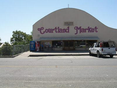
Started in downtown Rio Vista. The objective was to take an ez, flat ride out to Courtland. Rather than putting in miles, hills, etc. the goal was to take a couple of ferries, eat a good sandwich at the Courtland Market, and ride some new roads (a loop around Sutter Island). I was a bit worried about fog, but it was just a little hazy and not that cold with very little wind, so the weather turned out to be pleasant - especially for January! Actually the Bay Area as a whole is experiencing record high temperatures for this time of year.

Rode onto the Real McCoy ferry (from Rio Vista to Ryer Island). The Delta is really a unique place - all farmland and small towns - pretty much another world from the other side of the river I live on (Antioch) and Sacramento as well. Mostly, I don't like flat rides, which is probably why I don't ride here that often. But, the Delta, with the exception of some of the busy main highways, has a lot of low traffic back roads. The ferry operator remarked that I was cheating by taking the ferry ride. Thoughts of riding a water bike entered my mind.


I had a dog come after me on the SE side of Ryer Island and put a little scare into me. Good thing he wasn't vicious as he had a good opportunity to take a bite out of my leg. Took the J-Mac ferry (cable towed) on to Grand Island. I noticed that the steel cable had an orange, plastic coating - obviously to prevent corrosion.


I rode past a rather well kept old Victorian home and the Grand Island Mansion.


I hear barking behind me and in my mirror I see a tiny white dog and a mid to large sized lab chasing me. Boy they went a long way before they gave up. That little guy's legs were moving so fast they were a blur. I was doing about 15-17 mph and they were keeping a constant gap. Hope I wore them out and they would get lost finding home (though I doubt that).

Went across two steel decked bridges to get across the river to Courtland. I don't like these bridges much. They can be very slippery when wet (not today though), and your front tire seems to wander around some. I worry about the tire falling into a gap, but have never had that happen (yet). I wonder why they call this place Courtland - must be that building with the columns that looks like a court house...

Got to the Courtland Market and ordered up a turkey sandwich and used the facilities. They make good sandwiches. They used to be really cheap (especially for one with plain bread), but upped their prices a while ago so they are reasonably priced, but cheap no longer. Sat outside on the bench and ate before heading back. I remember on a past ride my buddy Bob joking this loud and funny oriental fellow in the store about raising his prices. It was funny.


My objective was to do a loop around Sutter Island. Unfortunately, Google Maps shows a road that is no longer there (the sign said "Not a through road"). The Delta has a lot of dirt roads and private roads too, which are shown on Google Maps as regular roads so you really have to have a Plan B if you're out exploring like I was.

Plan B: ride up to the North end of Ryer Island, cross the bridge, take the Hwy 84 around the West end of the island, and take the Real McCoy back to Rio Vista. The road is straight and a bit boring on this stretch to Ryer Island. There's no waterways to capture your attention - nothing but farm fields. There was another road (Waukeena) that I could have taken, but I'm glad I didn't because I found out when I got to the bridge, that somewhere along the way, it turns to dirt. Crossed the bridge and took a break. By now it was getting nice and warm, and I was a bit overdressed (long sleeved undershirt and knee warmers). While riding I felt comfortable, though.


This side of Ryer Island is a California numbered highway (Hwy 84), and the pavement is pretty good, including a several miles of fresh pavement up to the ferry. I had my eyes peeled for dogs, but saw none. Got on the ferry and had a nice, but short ride across. Got back downtown and drove back home.

Another nice day and a good ride. I thought the ride was going to be about 50 miles but it turned out to be about 39. I must have planned it out wrong in ridewithgps.com (highly recommended).